
Off-roading is a vast activity that is not limited to a certain region; there are chances of getting lost; so, you must use the best GPS, which will keep you on track. What is the best GPS for Off-Roading?
The best GPS systems which guide your off-road journey are :
- Magellan TRX7 CS PRO
- Garmin Oregon 750t
- Garmin Overlander
- Lowrance HDS-7 Live Chart Plotter
- Trail Tech Voyager Pro
The GPS systems will save you from getting lost in strange areas. It is always recommended to use any of the GPS in your off-road vehicle for your safety.
Why Is GPS Required During Off-Roading?
Off-road enthusiasts often embark on long journeys searching for secret and remote places. In their pursuit of surpassing their peers and exploring new territories, they may find themselves in unfamiliar and isolated locations. GPS becomes vital in such situations, allowing them to stay on track and achieve their goals. Without GPS, they could easily veer off course and encounter difficulties in finding their way back.
One of the key advantages of using GPS during off-roading is the ability to save and trace routes. GPS systems record and store data about your journey, allowing you to retrace your steps whenever necessary.
This feature is precious when exploring remote areas where landmarks may be scarce. By having a reliable record of your routes, you can confidently navigate back to familiar terrain and avoid becoming lost.
GPS devices accurately pinpoint your location, making them indispensable for off-roaders.
They provide precise coordinates and real-time information about your position, direction, and distance to your destination. This accuracy is crucial when traveling through challenging terrain, as it enables you to make informed decisions and choose the best routes to reach your intended destinations.
It allows you to focus more on enjoying the journey and the natural surroundings rather than constantly worrying about finding your way back. This peace of mind enhances the overall off-roading experience and enables you to immerse yourself in the adventure fully.
Types of Off-Roading GPS:
Before using this modern technology, you must know the types of off-roading GPS. Following are the types of off-roading GPS.
Type 1- In-Dash Type:
This type of system remains fixed to the vehicle, and you can not take them on the hiking trip. One of the major disadvantages of this type is that you can not download new maps as they are locked to a provider. Built-in GPS devices are often attached to new vehicles.
Type 2- Smart Device Type:
Navigation apps are easily available on many phones and tablets; they are not expensive. The most important feature that attracts a buyer is downloading multiple map sources and geo-tag photos. Proper cell coverage is required for this system, and it depends heavily on battery life to work properly.
Type 3- Portable Type:
You can keep these portable units within your pockets and can take them anywhere. These units don’t have a wide display. One of the best portable GPS devices’ main features is that they are tough and have decent battery life for a long journey. Some of the models also hold features such as a compass, altimeter, and a few more.
5 Best GPS for Off-Roading:
This section will elaborate on the main features of the best available GPS as per our regressive research and hands-on experience. After going through this section, you will be able to select the best GPS to go off-roading.
1. Magellan TRX7 CS PRO:
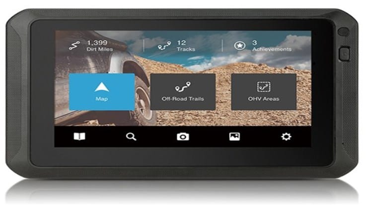

Magellan TRX7 CS Pro GPS is an exceptional device for off-roading enthusiasts. With its advanced features and rugged construction, the TRX7 CS Pro offers unparalleled navigation capabilities, making it an indispensable companion for off-road adventures.
Design and Durability:
The Magellan TRX7 CS Pro features a ruggedized IP54 casing, ensuring its resilience against water, dust, and shocks. Measuring 5.2" x 8.3" x .82" (132mm x 210.7mm x 20.9mm) and weighing 15.34 ounces (435g), this device is compact and lightweight, allowing for easy portability during your off-road journeys.
The robust construction and water resistance adds a layer of reliability, providing peace of mind even in challenging terrains and weather conditions.
Display and Interface:
Equipped with a vibrant 7-inch touchscreen display, the TRX7 CS Pro offers excellent visibility in both daylight and low-light situations. The high-resolution display ensures clarity in map details, making navigating trails and interpreting terrain features effortlessly.
The intuitive user interface enables easy operation and quick access to essential functions, ensuring a seamless and user-friendly experience.
The Magellan TRX7 CS Pro combines turn-by-turn trail and street navigation, making it versatile for off-road excursions and everyday use.
With over 160,000 preloaded designated OHV routes, including 4WD, ATV, motorcycle, and snowmobile trails, you can explore a vast network across the USA. The device's comprehensive trail database and the ability to search and save trails provide valuable information for planning your off-road adventures.
Camera and Recording Features:
One standout feature of the TRX7 CS Pro is its built-in 8MP rear-facing camera with an LED flash. This camera automatically starts recording when approaching trails, capturing stills, panoramas, and videos of your off-road experiences.
The instant video playback feature lets you review your recordings on the device, reliving your extraordinary performance. Additionally, optional recording modes, such as gauge overlay and time-lapse, enhance the adventure video capabilities, adding extra excitement to your off-road memories.
Online Community Track Database:
The TRX7 CS Pro provides access to the online community track database via TRX Trailhead. This platform allows you to discover and explore crowd-sourced tracks, plan on- and off-road routes, and access valuable trail information shared by fellow off-roaders.
By contributing and publishing your tracks, waypoints, and observations, you can actively participate in building a robust off-road community and share your experiences with like-minded adventurers.
Mapping and Updates:
The TRX7 CS Pro features high-resolution (10M) 2D topo and 3D base maps of the USA and Canada, providing detailed and accurate terrain representation.
The device comes preloaded with these maps, and users can also benefit from free map updates, ensuring access to newly loaded trails and route information. Wirelessly downloading updates via Wi-Fi provides a hassle-free and convenient experience, keeping your device updated with the latest trail data.
Additional Features:
The Magellan TRX7 CS Pro offers a range of additional features to enhance your off-roading experience. The device allows you to create off-road waypoints, marking meetup locations, scenic views, campsites, and obstacles.
The companion app, available for iOS and Android, provides seamless access to your account, allowing you to search, save, and view your position even when away from the TRX7 CS Pro device. The Backtrack feature ensures your safe return by guiding you back to your current track’s trailhead or starting point.
Here I lay down a detailed chart highlighting the main and unique features of the Magellan TRX7 CS Pro:
Magellan TRX7 CS PRO Feature | Description |
Ruggedized IP54 Casing | Water, dust, and shock-resistant casing |
7" Touch Screen Display | Extra-large, vibrant, sunlight-readable display |
Turn-by-Turn Trail and Street Navigation | Visual and audible guidance for off-road trails and streets |
Over 160,000 Preloaded Designated OHV Routes | Extensive collection of 4WD, ATV, motorcycle, and snowmobile trails |
Built-in 8MP Rear-Facing Camera | Auto-start recording when approaching trails, with instant video playback |
Optional Recording Modes | Gauge overlay and time-lapse modes for adventure video recording |
Hi-Res (10M) 2D Topo and 3D Basemap | High-resolution terrain maps of the USA and Canada |
Online Community Track Database | Access to crowd-sourced tracks, observations, and rankings via TRX Trailhead |
Create Off-Road Waypoints | Mark meetup locations, scenic views, campsites, and obstacles |
Companion App | iOS and Android app for accessing account, search, and position tracking |
Backtrack | Guidance to safely navigate back to the trailhead or starting point |
RAM Dual Mount | Quick release power cradle with suction cup and rail mount for secure attachment |
Battery Capacity | 4000mAh Lithium-ion rechargeable battery |
Expandable Memory | Up to 128GB on microSD card |
Water Resistance | IP54 rating for protection against water splashes and dust ingress |
Free Map Updates | Regular updates with newly loaded trails for accurate navigation |
Social Sharing | Share progress, photos, and updates on Twitter and Instagram |
Intuitive User Interface | Easy-to-use interface for seamless navigation and operation |
Pros | Cons |
Waterproof and shock-resistant casing | Difficult to decipher trail numbers/names on the map |
Built-in 8MP camera for trail recording | Memory card fills up quickly |
Street navigation functionality | Screen goes black when recording while plugged into power |
Preloaded with over 160,000 designated OHV routes | Outdated maps |
High-resolution 7-inch touch screen | Interface for accessing advanced features is not intuitive |
Track recording and community publishing | Poor customer support |
Free map and software updates |
|
2. Garmin Oregon 750t:
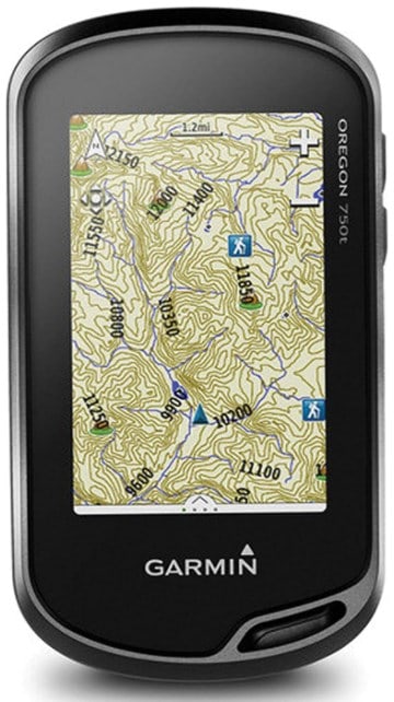

The Garmin Oregon 750t is an ideal companion for off-roading adventures. The Oregon 750t is a top contender among GPS systems for off-roading enthusiasts with its impressive features, rugged design, and user-friendly interface.
Let me explore its main features and why it deserves a spot on the list of the best GPS for off-roading.
GPS and GLONASS Positioning:
The Oregon 750t utilizes GPS and GLONASS satellites, ensuring accurate positioning and reliable navigation even in challenging environments.
3″ Sunlight-Readable Touchscreen:
The device boasts a 3-inch sunlight-readable touchscreen display, allowing clear and easy navigation, even in bright outdoor conditions. The reflective display technology further enhances visibility by utilizing external light.
- Preloaded Topographic Maps: The Oregon 750t comes preloaded with TOPO U.S. 100K topographic maps, providing comprehensive coverage of the terrain, trails, and points of interest for off-roading adventures.
- Dual Orientation Display: With the ability to switch between landscape and portrait views, the Oregon 750t offers flexible display options, allowing you to choose the orientation that best suits your preference.
- Wireless Connectivity: The device features expanded wireless connectivity options, including Wi-Fi, Bluetooth, and ANT+. This enables convenient software downloads, smart notifications, and seamless data sharing with other compatible Garmin devices.
The Oregon 750t Feature | Description |
GPS and GLONASS Positioning | Utilizes both GPS and GLONASS satellites for accurate positioning and navigation. |
3" Sunlight-Readable Touchscreen | Bright and easy-to-read 3-inch touchscreen display with reflective technology for enhanced visibility in various lighting conditions. |
Preloaded Topographic Maps | Comes preloaded with TOPO U.S 100K topographic maps, offering detailed terrain information for off-roading adventures. |
Dual Orientation Display | Display can be adjusted to landscape or portrait mode based on personal preference and convenience. |
Wireless Connectivity | Expanded wireless connectivity options including Wi-Fi, Bluetooth, and ANT+ for software downloads, data sharing, and smart notifications. |
Built-in 8 Megapixel Camera with Geo-Tagging | Capture photos of your off-road adventures with an autofocus camera that automatically geotags each image for easy location tracking. |
Paperless Geocaching Software | Integrated software for paperless geocaching, allowing you to store and access cache details directly on the device. |
10,000 Waypoint Memory | Ample storage capacity for storing up to 10,000 waypoints, ensuring you can record and navigate to multiple points of interest. |
microSD Card Slot | Expandable memory with a microSD card slot to load additional maps, such as TOPO maps, BlueChart charts, or City Navigator data. |
Bluetooth and ANT+ Compatibility | Connect wirelessly to compatible devices for data transfer, including photos, geocaches, adventures, routes, and custom maps. |
Water-Resistant (IPX7) | Rugged and water-resistant design with an IPX7 rating, protecting the device from splashes, rain, and brief submersion in water. |
Battery Options | Power the device using either two AA batteries or a rechargeable NiMH pack for flexible and reliable energy sources. |
Garmin Basecamp Software Compatible | Compatible with Garmin Basecamp software for advanced route planning, data analysis, and customization of maps and waypoints. |
Pros | Cons |
Accurate GPS and GLONASS positioning | Touchscreen performance may be affected when wet |
Preloaded topo maps for easy navigation | Limited battery life when using the touchscreen |
Dual orientation touchscreen | Relatively expensive compared to other models |
Wireless connectivity for data sharing | |
Built-in 8-megapixel camera for geotagging |
|
Paperless geocaching capabilities | |
Ample waypoint memory |
|
Expandable memory with microSD card slot |
|
Water-resistant design | |
Compatible with Garmin Basecamp software |
|
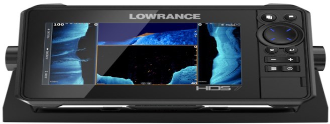
3. Lowrance HDS-7 Live Chart Plotter:

Designed specifically for high-performance off-road navigation, this GPS device offers a range of features to enhance your off-roading experience.
I will explore the key aspects of the Lowrance HDS LIVE 7 and why I recommend this device in the list of top GPS systems for off-roading.
Display and User Interface:
The Lowrance HDS LIVE 7 boasts a 7-inch, multi-touch, SolarMAX™ HD screen, providing a clear and vibrant display even under direct sunlight and through polarized sunglasses.
The high-definition resolution of 1024 x 600 ensures you won't miss any crucial details on your maps and trails. The user interface is designed to be user-friendly, with a simple menu layout and full operation through the multi-touch screen or keypad.
The responsive dual-core processor ensures fast chart redraws and quick response times, keeping you on track without lag.
Connectivity and Notifications:
Staying connected on your off-roading adventures is made easy with the wireless and Bluetooth® connectivity of the HDS LIVE 7.
You can receive smartphone notifications directly on the GPS display, allowing you to stay informed without constantly checking your phone. Whether it’s text messages or calls, you won’t miss any important updates while exploring the great outdoors.
The HDS LIVE 7 provides a comprehensive mapping and navigation experience. With color trails on the map, you can easily track your speed and identify areas where you need to slow down.
The Quick Access Control Bar enables one-touch access to system controls, making adjustments on the go a breeze. For audio enthusiasts, the SonicHub®2 audio server connectivity allows you to enjoy your favorite tunes while on your off-roading journey.
Compatibility and Upgrades:
The HDS LIVE 7 is compatible with NMEA 2000® engine support, ensuring seamless integration with your off-road vehicle’s engine system. It also offers two microSD card slots, providing ample storage for optional mapping upgrades.
If you’re looking for even more detailed land-based mapping, the optional Topo Insight Pro Mapping is a valuable addition, ensuring you never miss a detail and have a clear understanding of what lies ahead.
Additional Features:
The HDS LIVE 7 comes with the Point-1 BAJA GPS Antenna, featuring an integrated compass for precise navigation. This package offers enhanced accuracy, especially in off-road terrains where accurate navigation is essential.
Additionally, the optional LR-1 Remote Control allows you to pan the map, zoom in/out, and conveniently adjust while on the move.
Let me also provide you with the main specification of the HDS LIVE 7 in the following chart:
Lowrance HDS LIVE 7 Feature | Description |
Display | Full high-definition SolarMAX™ HD multi-touch screen with wide viewing angles, ensuring clear visibility in various lighting conditions |
User Interface | User-friendly interface with simple menu layout and full operation via multi-touchscreen or keypad |
Processor | Powerful dual-core processor for fast chart redraws, quick response times, and overall smooth performance |
Connectivity | Wireless and Bluetooth® connectivity for seamless integration with smartphones, enabling smartphone notifications on the GPS display |
Color Trails | Color-coded trails on the map to track speed variations and identify areas where adjustments may be needed |
Quick Access Control Bar | One-touch access to system controls for easy and quick adjustments while on the move |
SonicHub®2 Audio Server | Connectivity for audio enthusiasts, allowing the enjoyment of favorite tunes during off-roading journeys |
NMEA 2000® Engine Support | Compatibility with NMEA 2000® engine systems for integration and monitoring of engine data |
Mapping Upgrades | Two microSD card slots for optional mapping upgrades, providing additional mapping capabilities and detailed land-based mapping |
Point-1 BAJA GPS Antenna | Included antenna with integrated compass for precise off-road navigation |
Optional LR-1 Remote | Optional remote control for convenient map panning, zooming, and adjustments on the fly |
Topo Insight Pro Mapping | Optional mapping upgrade for detailed land-based mapping, catering specifically to off-road enthusiasts and racers |
You can easily get the view of the screen during sunlight because it is very bright and well presented. Among the added features of this device, the most important added feature is the display of smartphone notifications. If you want to process your journey with this system, you feel free to proceed as it is one of the best systems available.
Lowrance HDS LIVE 7 Pros | Lowrance HDS LIVE 7 Cons |
High-definition SolarMAX™ HD multi-touch screen | Relatively higher price point compared to some competitors |
Wide viewing angles for clear visibility | Large screen size may not be suitable for all setups |
User-friendly interface with intuitive controls | Some users may prefer physical buttons for navigation |
Fast processor for quick response and chart redraws | Limited internal storage for maps and data |
Wireless and Bluetooth® connectivity | Some users may find the interface overwhelming |
Color trails to track speed variations | Requires additional accessories for full functionality |
Quick Access Control Bar for easy adjustments | |
SonicHub®2 audio server connectivity | |
NMEA 2000® engine support | |
Optional mapping upgrades |
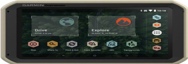
4. Garmin Overlander:

Garmin has produced high-quality off-road GPS units over some time. Garmin Overlander is one of the best units that Garmin produces. As an off-road enthusiast, it must be included in your list. This section will analyze the performance of this GPS and explicitly the main features of this system.
Design and Display:
The Garmin Overlander GPS boasts a 7-inch color touchscreen that provides turn-by-turn directions for on-road navigation and topographic maps for off-road guidance across North and South America.
The display is clear, vibrant, and easy to read, ensuring you can navigate effortlessly, even in challenging lighting conditions. With a resolution of 1024 x 600 pixels and a responsive touch interface, the Garmin Overlander delivers a seamless user experience.
Equipped with preloaded topographic maps, the Garmin Overlander GPS goes beyond traditional road maps by indicating public land boundaries and 4×4 roads.
This feature allows you to venture off the beaten path and confidently explore remote areas. The device supports additional map downloads, including USGS quad sheets, through the Garmin Explore app and its 64 GB internal storage.
Customization and Alerts:
One notable feature of the Garmin Overlander GPS is its ability to customize routing based on the size and weight of your vehicle. This ensures you receive accurate navigation instructions tailored to your specific off-road setup.
The device also provides alerts for forthcoming weight limits, bridge heights, steep grades, sharp curves, and more, allowing you to navigate challenging terrain safely and efficiently.
Integration and Connectivity:
The Garmin Overlander GPS offers seamless integration with other Garmin devices and apps to enhance your off-roading experience.
Additionally, you can pair the device with up to four BC™ 35 wireless backup cameras (sold separately) to have a clear view of what’s behind you, enhancing safety during maneuvers.
Durability and Versatility:
Built to the U.S. military standard 810 for thermal and shock resistance, the Garmin Overlander GPS is engineered to withstand tough conditions.
It can be mounted anywhere using the included powered magnetic mount, suction cup, and 1-inch RAM ball adapter, ensuring maximum versatility and convenience.
With an IP5X dust rating and its ability to withstand extreme temperatures, this GPS device is built to accompany you on all your off-roading adventures.
You can get the main specifications and features below:
Garmin Overlander GPS Specification | Details |
Color Screen | Yes |
Internal Memory | 64 gigabytes |
Wireless Communication | Yes |
Touch Screen | Yes |
Expandable Memory | Yes |
Best Use | Multisport, Navigating |
Batteries | Rechargeable lithium-ion |
Number of Waypoints | 10,000 |
Preloaded Map | Road / Topo |
Battery Type | Lithium Ion |
Altimeter | Pressure-based |
Quad Helix Antenna | Yes |
Position Accuracy | 3 meters |
Dimensions | 7.84 x 4.79 x 0.93 inches |
Average Battery Life | Up to 3 hours |
Visual Map Display | Yes |
OS Compatibility | Windows / Mac, Android, iOS |
Custom Points of Interest | Yes |
Number of Routes | 250 |
Screen Pixels | 1024 x 600 |
Lane Assist | Yes |
Text To Speech | Yes |
Compact Antenna | Yes |
Weight | 15.4 ounces |
You can also carry out the synchronization of data when in the range of WiFi connection. Using this device, you will not require a cell signal to chart your route to a campsite.
Garmin Overlander GPS Pros | Garmin Overlander GPS Cons |
Versatile Off-Roading GPS | Limited Battery Life |
Extensive Map Options | Additional Map Purchases |
Customizable Routing | Reliance on External Devices |
Durability and Mounting Flexibility | Limited Connectivity Options |
Compatibility with Accessories | Costly |
5. Trail Tech Voyager Pro:

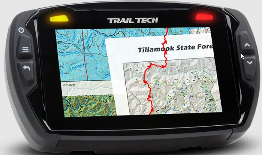
The Trail Tech Voyager Pro GPS is a standout choice, offering a range of advanced features tailored to meet the needs of power sports enthusiasts.
Design and Display:
The Voyager Pro boasts a rugged and durable design that can withstand the rigors of off-road adventures.
Its 4-inch color touchscreen display is sunlight-readable, ensuring excellent visibility even in bright outdoor conditions. The compact dimensions of 144 x 90 x 47mm and a weight of 410g make it portable and easy to mount on your power sports vehicle.
Equipped with preloaded topo maps, the Voyager Pro provides detailed and accurate off-road navigation. The inclusion of hill-shading adds depth to the maps, helping you visualize the terrain more effectively.
Whether you’re tackling rocky trails or exploring dense forests, the GPS will keep you on the right track.
Buddy Tracking and Group Ride Technology:
One of the standout features of the Voyager Pro is its patent-pending Buddy Tracking and Group Ride technology.
With real-time buddy tracking, you can stay connected with your riding group and monitor their location on the trail. This feature enhances safety and ensures that everyone stays together during your off-road adventures.
Bluetooth Connectivity and Media Control:
The Voyager Pro offers Bluetooth connectivity, allowing you to pair your smartphone for seamless audio playback and hands-free calling.
You can control volume, song playback, and access call history and messaging features right from the GPS. It also supports compatibility with popular Bluetooth headphones and headsets, enhancing your riding experience.
Vehicle Integration and Gauge Screens:
Integrating with your vehicle’s systems, the Voyager Pro provides essential information through its gauge screens.
You can monitor speed, temperature, distance, elevation, engine temperature, and voltage, keeping you informed about your vehicle’s performance. This feature helps you make informed decisions and optimize your off-roading experience.
Compatibility and Mounting Options:
The Voyager Pro is compatible with RAM Mounts, offering versatile and secure mounting solutions for various power sports vehicles.
It also works seamlessly with CalTopo.com GPX tools, enabling easy import and export of GPS data for trip planning and analysis. Additionally, Polaris vehicle owners can take advantage of the compatibility with POLARIS RIDECOMMAND® Group Ride for enhanced riding experiences.
Trail Tech Voyager Pro Specification | Description |
Power | External Power Input: 8V-16V DC; Internal Battery: 3.7V 3100 MAH LI-ION |
Battery Life (100% Backlight) | 45 Minutes |
Display Range | Speed: 0-320 KMH; Distance: 0-999,999 KM; Elevation: 9,000 METER; Engine Temp: -40-210°C; Accumulated Run Time: 0-99,999 HR; GPS Record Rate: 1,2,5 SEC / 1,5,10 M |
Physical Dimensions | 144 x 90 x 47mm |
Screen Size | 480x272px, 101mm diagonal, 50.5mm x 89.2mm |
Battery Life (Typical Use) | 1 Hour |
Physical Weight | 410g |
Operating Temperature | 0-60°C |
Mounting Pattern | AMPS 30X38MM |
Environmental Rating | IP67 |
External Memory | microSD up to 64GB |
Internal Memory | 32GB |
Charge Temp Range | 0°C-55°C |
Functions | Speed, Distance, Elevation, Engine Temp, Accumulated Run Time, GPS Record Rate |
Battery Charge Time | 3-8 Hours |
Storage Temperature | -20-80°C |
Trail tech voyager pro can also track the speed by the use of wheel senor. You can check the speed of your vehicle with this system, and it will help you adjust the ideal speech to avoid unwanted incidents.
Trail Tech Voyager Pro GPS Pros | Trail Tech Voyager Pro GPS Cons |
Large 4" color touchscreen display | Limited battery life (45 minutes at 100% backlight) |
Buddy Tracking feature for real-time tracking of fellow riders | Limited internal battery capacity |
Bluetooth connectivity for phone audio and wireless headset control | Limited operating temperature range (0-60°C) |
Integrated vehicle sensors and gauge screens for accurate data monitoring | Relatively heavy weight (410g) |
Compatibility with RAM Mounts and CalTopo.com GPX tools for versatile mounting options and map integration | Limited storage temperature range (-20-80°C) |
Topo maps and sunlight-readable display |
Principle of The Off-Road Global Positioning System:

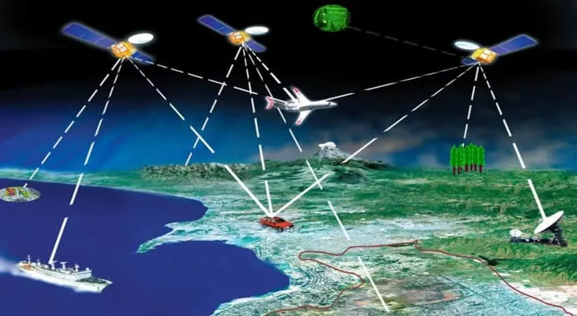
The global positioning system is comprised of 30 satellites that keep on orbiting the earth. One of the best features of this GPS is that it is user-friendly. You don’t need to do a separate course for this GPS as you can easily comprehend this system within few days.
The functioning of GPS is like that; where ever you are roaming on the planet, your GPS device is always under the range of four GPS satellites. These satellites send a signal that your device receives, and in this way, the given distance is calculated accurately. The process called Trilateration is used to point out your exact location.
Nowadays, this GPS is much more accurate with the advancement in technology. The accuracy of these available GPS systems is increased due to the increase in software strength.
Use of GPS During Off-Roading:

GPS will help you to stay on track throughout your journey. There are many uses of this technology; with the help of this technology, you can find new trails. This system will be of great benefit when you plan your journey with your buddies. The best GPS will help you to stay in touch with your buddies.
There are no chances of getting lost by using this system, so you must use the best GPS to stay safe. Your life is much more important than a few dollars, so you must spend some money to get the best GPS. You must go with this system as it saves you from getting lost.
| Use of GPS system | Advantages |
|---|---|
| Keep on track | If you are using one of the best GPS systems, then you are safe. You can prolong your journey and can proceed to many unknown places with confidence. GPS will track your location and guide you properly. You will remain on track with the help of this system. |
| Grant prediction | With the help of this advanced technology, you will attain knowledge about every route. After having a good idea about the locations of the road, you can pre-plan your trip and select the most appropriate route for your journey. |
| Communication | With the advancement in technology, now there is no way to get lost. You can get in touch even if you are far away from the cities. Even in low signal areas, you can get in touch with your buddies. |
Final Thought:
This article has analyzed the main features of some of the best available GPS systems for off-roading. After skimming through this article, you will be able to compare these systems and select the best out of them. You must not proceed with your journey without selecting the best GPS.
The best system will protect you from getting lost and protect your life. The decision of final selection is totally up to you. If you are willing to have a great trip, you must not care about spending more on the best GPS as it saves you from many troubles.
Also Read:
What Type of Suspension is Best for Off-Roading? Top 10 Brands
Frequently Asked Questions(FAQs):
What is the best 4WD GPS?
There are many high-quality GPS systems. It isn’t easy to crown any one of them as the best available GPS. These GPS systems are of great importance as they save you from getting lost and keep you on track; otherwise, you can put yourself in trouble without using these GPS systems.
But which GPS is the best of all. There is no fixed answer to this query; we select the most appropriate GPS based on certain factors. The best 4WD GPS is the Hema Navigator HX-1. The major quality of this system is that it comes pre-loaded, and you must understand the importance of this system; it is the only system that comes pre-loaded otherwise, there is no other system that comes pre-loaded.
Due to this feature, Hema Navigator is prioritized over other GPS systems. You must know that this comes pre-loaded with more than 110 4WD and touring maps. This system is the best in use; this will save you time because you can use this system immediately after unpacking this. The mapping system of this is incredible as they are working on it for many years. The mapping system of Hema covers almost all of Australia, state, regions, and national park maps.
Can you use Google maps for off-roading?
Off-roading is a broad activity that is not limited to any specific area or region. You can use Google Maps to track out your location. Off-roading is all about remote areas, and in those areas, it is deemed necessary for you to have a location checker; otherwise, you will find yourself in deep trouble.
But you acknowledge that it is not the best system to track your location. You can not completely rely on this system, but it is one of the useful apps to hold during off-roading. You can also use this system offline, but you first have to download the maps; otherwise, it will not show the maps. So, it is clear that you can use google maps for off-roading but in a limited way. Before proceeding to your journey with this system, you must understand both the positive and negative features of this app.
How to find out the failure of GPS?
If you are trying to find out the problems associated with your GPS, you must have to gain the basic knowledge of this system for better analysis of the system’s functioning. The main purpose of this system is to find out the exact location of a rider and help him be on track.
During off-roading, if GPS is not responding properly and imparting false information, then it must be subjected to malfunctioning, and you need to address this situation. Otherwise, you will not be able to recover. If you ignore this glitch and keep on proceeding, it can be dangerous for you. You can find yourself nowhere.
It could be bad for your vehicle as well; you will not seek any help as you are unaware of the location. This problem occurred when this system did not update timely. This problem is serious; failure to navigate properly can put your life in trouble; if you want to avoid any unwanted incidents, you must sort out this problem. You must use the best available system as there are fewer chances of malfunctioning the best available systems.


This is Surya. I am an experienced off-roader. I have been off-roading for many years across several terrains. I am passionate about 4×4 driving and want to share my knowledge and experience with others.
My goal is to provide you with the most comprehensive and unbiased information about off-roading.
I curated this article through my personal experience and expertise, and I hope it helps you with what you are looking for.
 (+91)9123743026
 24/1 Nibedita Sarani. M.B. Road, Kolkata- 700051, India
The Best Small and Mid SUV for Off-Roading in 2021- Best in Business – Offroadhandbook
Friday 3rd of December 2021
[…] What to Know Before Going Off-Roading? Tips from the ExpertTop 5 Best GPS for Off-Roading: Detailed Analysis […]
Best Off-Roading Kit- Safety, Recovery Kit and More – Offroadhandbook
Sunday 14th of November 2021
[…] know the way out. So, to prevent this, you need to bring a navigation unit with you in the form of a GPS or offline map guide of the trail you have set forth for trekking. Otherwise, be prepared to be lost in the […]
Can Cybertruck Go Off-Road? Know From Tesla’s Aspect – Offroadhandbook
Sunday 15th of August 2021
[…] Top 5 Best GPS for Off-Roading: Detailed AnalysisCan 2WD Go Off-Road? Understand the Dynamicity […]
What to Carry During Off-Roading? Don’t Forget Any of These – Offroadhandbook
Saturday 14th of August 2021
[…] help you navigate, and if you require overcoming a challenge in off-roading, a good set of tires will help you out. […]
Top 10 Most Extreme Off-Road Paths in 2021- Confront Yourself – Offroadhandbook
Friday 23rd of July 2021
[…] you have a track record of going in extreme winters, you can make your way into Whipsaw Trail with GPS and safety equipment.You can have your recovery gear, safety equipment, and GPS by following the […]